-
Annette Dionne, Last of the Celebrated Quintuplets, Dies at 91 - 9 mins ago
-
The Race to Save the Sacramento Mountains Checkerspot Butterfly - 53 mins ago
-
A bear has been under an Altadena home for a month. A trap caught the wrong one. - about 1 hour ago
-
How to Watch Czech Republic vs Canada: Live Stream 2026 IIHF World Junior Hockey Championship, TV Channel - about 1 hour ago
-
Perry Bamonte, Guitarist and Keyboardist in the Cure, Dies at 65 - 2 hours ago
-
Ashlee Buzzard pleads not guilty to murder of 9-year-old Melodee - 2 hours ago
-
How to Watch Bulls vs 76ers: Live Stream NBA, TV Channel - 2 hours ago
-
Some G.O.P. senators join Democrats in urging Trump to adopt hard line with Putin. - 2 hours ago
-
Winter storm buries Wrightwood, drenches SoCal - 2 hours ago
-
A Wealth Tax Floated in California Has Billionaires Thinking of Leaving - 3 hours ago
Texas flood watch: Map shows cities facing potential threat
A flood watch will go into place late Wednesday night for portions of South-Central Texas as rain moves through the area.
Newsweek reached out to the National Weather Service (NWS) via email for additional comment.
Why It Matters
Portions of South-Central Texas—including major metropolitan areas such as Austin and San Antonio—will be placed under a flood watch as forecasters warn communities of potentially hazardous rainfall and the threat of flash flooding.
The region experienced severe storms and devastating floods earlier this year, most notably in Kerr County.
Forecasters highlight that new rainfall could swiftly inundate rivers, creeks, and drainage systems, posing dangers to homes, roads, and public safety. Severe weather in this region has already led to loss of life and extensive evacuations earlier in 2025, underscoring the heightened risk currently facing millions of Texans.
What To Know
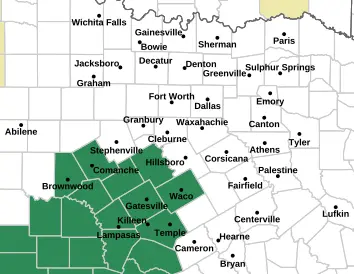
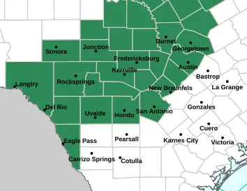
According to the NWS, Bandera, Bexar, Bell, Blanco, Brown, Burnet, Bosque, Comal, Comanche, Coryell, Edwards, Hamilton, Gillespie, Hays, Kendall, Kimble, Kerr, Kinney, Llano, Lampasas, Mason, Medina, McLennan, McCulloch, Menard, Mills, Real, San Saba, Sutton, Travis, Uvalde, Val Verde and Williamson counties are facing the watch starting overnight.
The watch comes as an upper-level storm system combines with above-normal atmospheric moisture to create rounds of rainfall in the region, the NWS says.
“Rainfall amounts of 1 to 3 inches with isolated totals of 6 to 8 inches are possible,” the watch warns. “Excessive runoff may result in flooding of rivers, creeks, streams, and other low-lying and flood-prone locations. Creeks and streams may rise out of their banks. Flooding may occur in poor drainage and urban areas. Low-water crossings may be flooded,” the NWS said.
A moderate risk of at least 40 percent for a flash flooding threat is also in place for a portion of the region, including Del Rio and Rocksprings.
Below are maps of the cities impacted by the flood watch going into place:


What People Are Saying
The NWS Austin and San Antonio office on X on Wednesday: “These are the most likely rainfall amounts most can expect late tonight through early Friday morning. The highest totals are expected over the southern Edwards Plateau and the western Hill Country. A Flood Watch goes into effect midnight tonight until 6 AM Friday. #txwx”
What Happens Next
Residents in affected counties are urged to keep monitoring official NWS alerts and local media and be prepared to “take action should flooding develop,” the NWS says.
Source link


