-
France Needs a New France - 31 mins ago
-
’60 Minutes’ Faces Backlash For Pulling Trump El Salvador Prison Segment - 38 mins ago
-
Powerball jackpot hits $1.6 billion on Monday. Oxnard market sells $2.3-million ticket - about 1 hour ago
-
Ole Miss Loses Coach to LSU Before College Football Playoff vs Georgia - about 1 hour ago
-
Élysée Palace Silver and Tableware Stolen by Steward, Prosecutors Say - about 1 hour ago
-
Baltimore Ravens Give Update on Lamar Jackson After Injury in Patriots Loss - 2 hours ago
-
Heavy Rains Bring Flooding to Northern California - 2 hours ago
-
Packers HC Matt LaFleur Gets Blunt About Bears Disaster - 2 hours ago
-
At Turning Point Fest, Vance Refuses to Take Sides in Fight Over Bigotry - 3 hours ago
-
NBA Receives Disappointing Update on 2025-26 Season: ‘Our Worst Fear’ - 3 hours ago
First Ever ‘Particularly Dangerous’ Weather Threat Hits Colorado
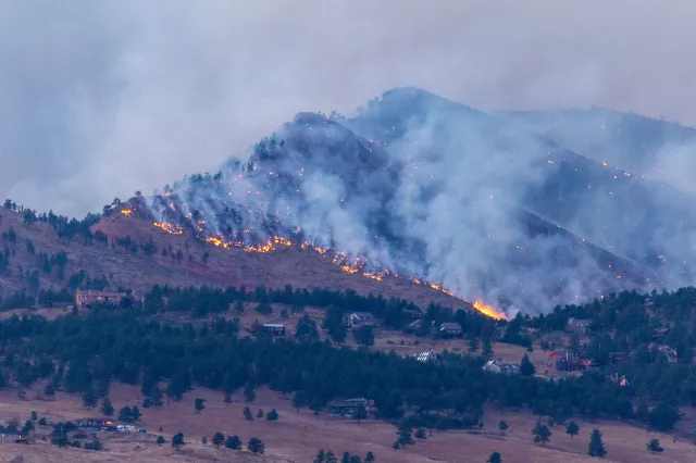
An extreme wildfire threat has prompted National Weather Service (NWS) meteorologists in Boulder, Colorado, to issue a “first-ever” Particularly Dangerous Situation alert for Colorado.
The rare message comes as much of the state has faced ideal conditions for rapid wildfire growth this week, with wind gusts exceeding 100 miles per hour. To make matters worse, relative humidity has plummeted to the single digits in some cases, creating a dry environment ideal for rapid fire spread. Although extremely strong wind gusts are not uncommon in December in Colorado, NWS warning coordination meteorologist Greg Heavener told Newsweek that snow typically blankets the dry grasses and finer fuels that feed a wildfire at this point in the year. However, Boulder has been unusually dry. A single snowfall event has occurred in the region, and the snow has long since melted.
Combined, the strong wind gusts and unusually dry conditions prompted NWS Boulder to issue the first-of-its-kind Particularly Dangerous Situation alert.
“PARTICULARLY DANGEROUS SITUATION Fire Weather,” NWS Boulder posted on X on Friday morning. “We rarely issue these Particularly Dangerous Situation Red Flag Warnings regarding potential for rapid wildfire spread in and immediately adjacent to the Boulder/Jefferson County foothills. Be ready to take swift action.”
A map included with the post showed that peak wind gusts would be felt immediately west of Boulder, including in cities like Jamestown and Nederland. Xcel Energy, Colorado’s largest energy provider, issued Public Safety Power Shutoffs for thousands on Wednesday to attempt to mitigate wildfire risk. As of 10:30 a.m. Eastern time on Friday morning, Heavener said there have been no reported fires.
“I hope people understand how volatile it is today and don’t have any activities outside that can produce a spark,” he said. “If it happens, the winds are going to take it fairly quickly from west to east.”
The highest risk will be through early to mid-afternoon, Heavener added.
“Very concerned for Colorado tomorrow, as the first-ever “Particularly Dangerous Situation” Red Flag Warning has been issued in the state for the foothills of Boulder and Jefferson Counties,” extreme storm chaser Colin McCarthy posted on X on Thursday. “Winds may gust up to 105 mph, with humidity dropping into the single digits. This comes on the heels of record warmth and dryness across the Colorado Front Range in recent weeks. Any fire that starts in these conditions could rapidly explode into a life-threatening wildland–urban interface fire.”
Red flag warnings remain in place across The Centennial State. Another component to the Particularly Dangerous Situation alert is the sustained, consistent nature of the winds currently battering Colorado. During the summer when wildfires are more common, although fuels are dry, Heavener said winds are brief in nature.
“Such conditions may be a longer duration than usual, with potential for low humidity to extend well into the evening hours,” NWS Boulder said in its red flag warning.

Source link


