Portions of Pennsylvania are under an ice storm warning on Friday night going into Saturday morning as the National Weather Service (NWS) warns of possible “slick and hazardous” conditions.
Newsweek reached out to the NWS via email for comment Friday night.
Why It Matters
Severe winter weather is presenting significant hazards across Pennsylvania, as the NWS issues multiple ice storm warnings and advisories for the region.
Residents, travelers, and utility providers face potentially elevated risks of power outages, hazardous road conditions, and vehicle restrictions in counties identified as most at risk. Understanding where these warnings are in effect is crucial as post-holiday travel collides with potentially hazardous ice accumulations and freezing precipitation.
What To Know
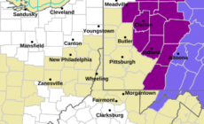
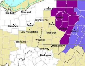
According to the NWS, portions of central and western Pennsylvania are under the warning until 7 a.m. ET Saturday.
“Significant icing” along with “Additional sleet accumulations up to a coating and ice accumulations between one tenth and one quarter of an inch,” are possible in the cities of DuBois, Somerset, Warren, St. Marys, Bradford, Clearfield, Johnstown, Ridgway, Tionesta, Franklin, Punxsutawney, Oil City, Ford City, Brookville, Indiana, Armagh, Kittanning, and Clarion, the NWS says.
Below are maps of the regions impacted by the warning:
Paired with these ice warnings, Winter Weather Advisories remain in effect for Harrisburg, Lancaster, Gettysburg, York and Altoona through Saturday morning. The NWS forecasts additional snow and ice potential across the region, with potential accumulations up to an inch possible in some locations.
“Roads, and especially bridges and overpasses, will likely become slick and hazardous. Power outages and tree damage are likely due to the ice. Travel could be nearly impossible,” the NWS says in the ice storm warning.
What People Are Saying
NWS Pittsburgh on X on Friday: “If you’re safely able, send us those ice measurements. Ice can be measured radially around branches as described below in steps 1-3, or on top of flat surfaces. Let us know which you measured!”
Meteorologist Cody Barnhart on X on Friday: “Our ice storm continues across PA and anything that’s been exposed is a sheet of ice. Major accidents state wide. Greencastle coming in slick @NWSStateCollege @mikestanislaw @MatthewCappucci @tornadopaigeyy @TOMRUSSELLCBS21”
What Happens Next
The NWS expects conditions to improve from west to east across Pennsylvania by Saturday afternoon.