-
Does the Iran War Put America First? - 13 mins ago
-
Ohio Announces Major Change to SNAP Benefits for Thousands - 23 mins ago
-
Man Killed After Fleeing Texas Border Patrol Checkpoint, Police Say - 57 mins ago
-
Wayne County Utah Deaths: Manhunt Underway as Classes Canceled, Warning Issued - 58 mins ago
-
Mom Couldn’t Work Out Who Was Moving Crib at Night—Then She Checked Babycam - 2 hours ago
-
Senate Thwarts Bid to Curb Trump’s War Powers on Iran - 2 hours ago
-
Shelter’s Tears at Owner’s Reason for Dumping ‘Wonderful’ Golden Retriever - 2 hours ago
-
Late Night Doesn’t Understand Why America Is Attacking Iran - 2 hours ago
-
Several of Labor Secretary Lori Chavez-DeRemer’s employees are under investigation for official misconduct under her leadership. - 3 hours ago
-
Rival Coach Makes Major Darius Acuff Claim After Arkansas-Texas - 3 hours ago
As teeth chatter across the U.S., Southern California is a hot spot: What to expect this week
While cold-stunned iguanas fall from trees in Florida and videos circulate of frozen “exploding” trees in the Northeast, Southern California is working up a sweat.
A midwinter heat wave has descended on much of the state and is expected to spike temperatures as much as 20 degrees above normal in the coming week.
The summer-like heat is thanks to a ridge of high pressure lingering high in the atmosphere that extends through the San Francisco Bay Area and into the Pacific Northwest. Meteorologists with the National Weather Service expect it to last through the end of the week and potentially through Super Bowl Sunday.
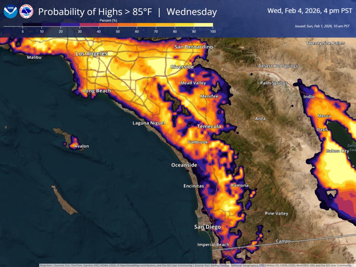
After a cooler Monday for the L.A. area, another push of warm weather may bring near-record temperatures by Wednesday — potentially reaching 90 degrees across the inland coast and valley areas of L.A. and Ventura counties, according to the weather service.

The thermometer is expected to tip above 85 degrees in much of Southern California on Wednesday, according to forecasters.
(National Weather Service)
The high-pressure ridge this week is expected to go “all the way up through Canada into southern Alaska,” said Carol Ciliberti, a meteorologist with the weather service. “It’s pretty impressive.”
Moderate Santa Ana winds, which may bring gusts up to 50 mph in the mountains, could add some additional heat to the region.
While downtown Los Angeles and Los Angeles International Airport tied daily record-high temperatures Friday, other parts of the United States set new daily record lows.
Nearly half of Americans were under cold weather advisories and extreme cold warnings Sunday. Frigid Arctic air, winter storms and a “bomb cyclone” dumped heavy snow on New England, triggered flight cancellations in North Carolina and tested the limits of power systems in the South.
Bomb cyclones typically occur when Arctic air creeps south and clashes with warm air, creating a storm that rapidly intensifies as its pressure suddenly drops — or “bombs out.”
It’s a common occurrence for the Northeastern U.S. This one is unique in how far south it reached.
Along the West Coast, air from the high-pressure shelf gets hotter as it sinks toward the ground. A similar phenomenon heats up Santa Ana winds as air from high above the Great Basin descends and races out to sea.
In the coming week, it’ll result in temperatures reaching roughly 15 degrees higher than normal in the Bay Area, and around 20 degrees higher than normal in Southern California. The trend in the Bay Area is expected to hold through Super Bowl Sunday, which will be held in Santa Clara.
“We’re going to see that high pressure really sticking around,” said Rachel Kennedy, a meteorologist with the weather service.
On game day, temperatures are still expected to be in the mid- to upper 60s for the Bay Area, but residents (and fans) might see some fog that morning, Kennedy said.
Despite the hot and windy weather in Southern California, vegetation is still holding enough moisture from the last rain that there is little risk of a major wildfire, said David Gomberg, a weather service meteorologist.
“You can still get small fires,” Gomberg said. “But the chances of it spreading into a major fire are minimal because of that moisture. It doesn’t spread easily.”
The weather service coordinates with fire agencies to rate fire risk, Gomberg said. The fire agencies take measurements of vegetation moisture in the field and forward the results to the weather service every two to four weeks.
The weather service’s models indicate that some light rain is in store for the region next week, with temperatures dropping to a more reasonable 5 to 10 degrees above average — although Ciliberti noted that without a crystal ball it was tough to say exactly when the moisture and cooler temperatures might arrive.
The Associated Press contributed to this report.
Source link


