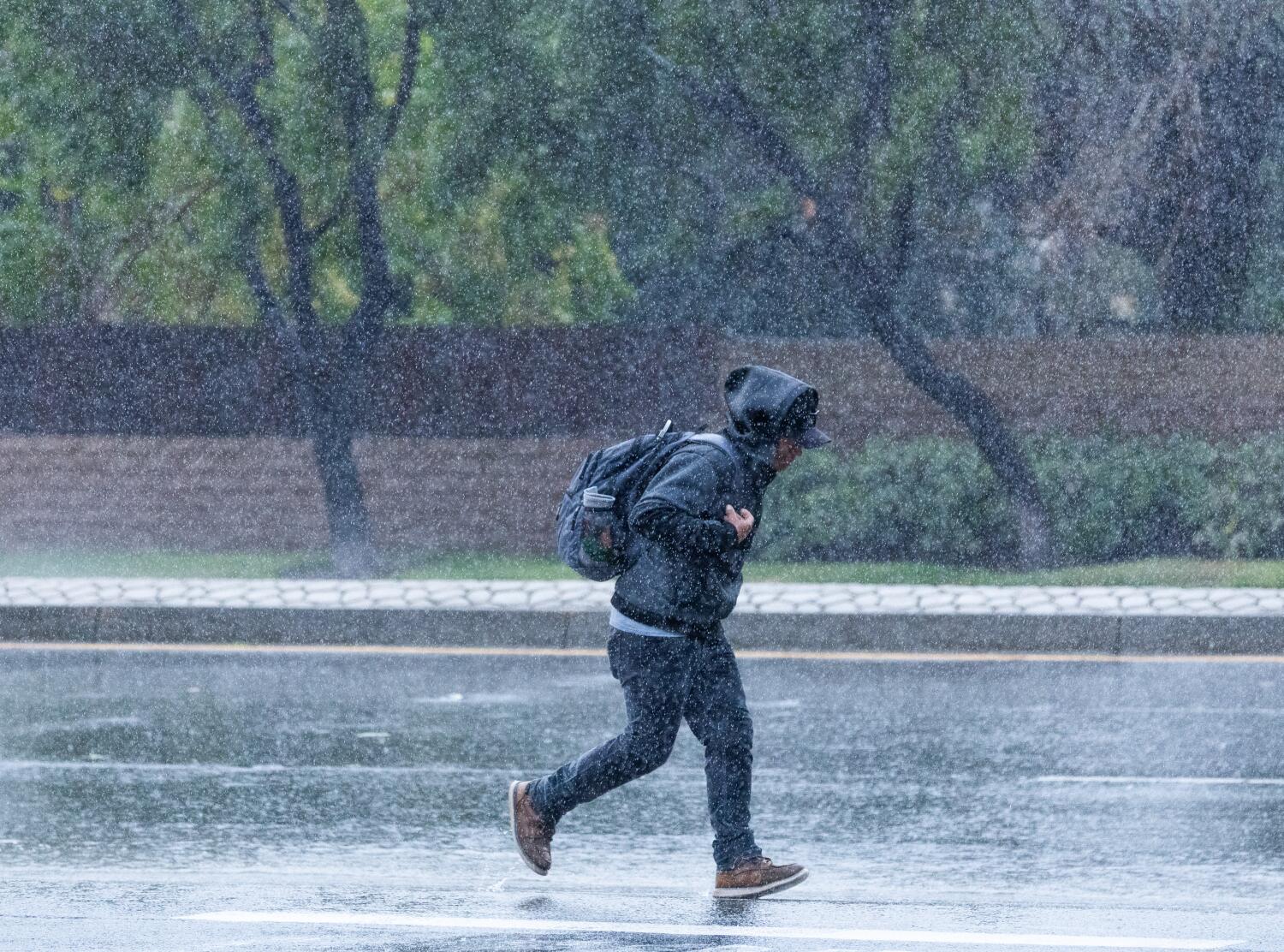
Evacuation warnings were set to go into effect across Los Angeles County on Thursday evening as an atmospheric river approached Southern California, bringing with it the potential to put an early end to fire season while also bringing fresh risks of flooding and mudslides.
Under the storm scenario deemed most likely by forecasters, downtown L.A. would see 2.62 inches of rain Thursday through Sunday, according to the National Weather Service. However, the forecast remains unsettled and varies widely.
There’s a roughly one-in-four chance of lower-but-still-notable precipitation, in the neighborhood of 1.39 inches, but an equal chance of a far-more-potent soaking of 4.81 inches over the same time period.
Either way, as far as fire season is concerned, “this will certainly help,” said Ryan Kittell, a meteorologist with the National Weather Service office in Oxnard.
“If we do end up getting the rainfall that we expect, this will certainly get us close to the end of the fire season,” Kittell said, and give Southern California a real buffer against a potential Santa Ana wind event.
That would be a far cry from last year, when Southern California grappled with a record dry streak over the fall and winter that left vegetation withered and primed to burn. Those “off the charts” conditions, combined with exceptionally erratic Santa Ana winds, fueled the rapid spread of the Eaton and Palisades fires, which rank among the deadliest and most destructive in California history.
Meteorologists say that Southern California needs 3 to 4 inches of widespread rain in the lower elevations for the high fire season to end. Downtown L.A. has already received 1.41 inches, almost all of it from just one stormy day in October.
Last year, downtown L.A. saw just 0.07 inches of rain from the start of October through mid-November. By Jan. 7 — the day the Eaton and Palisades fires roared to life — downtown had only received a cumulative 0.16 inches. It wouldn’t be until February, well after the blazes had already devastated Altadena, Pacific Palisades and Malibu, that the region saw enough rain to bring fire season to a close.
But the silver lining of the upcoming storm also carries a touch of gray. Rain of this magnitude could trigger damaging flows of mud and debris.
Evacuation warnings are in effect from 6 p.m. Thursday through 11 a.m. Sunday in areas near recent burn scars, due to the risk of mud and debris flows. This includes areas near the Palisades, Eaton, Kenneth, Sunset and Hurst fires that burned in January’s firestorm.
There are many reasons California has faced extraordinary fire risk in recent years. Climate change has fueled increasingly extreme heat, withering shrubs and grasses. Residential development has increased in fire-prone wildlands. Power infrastructure and failure to extinguish an arson-caused fire have been the suspected culprits behind recent devastating blazes.
All this heightens the stakes of California’s already delicate year-end dance between the Santa Ana winds — the strength and heat of which have turbocharged many a fire — and the arrival of the rainy season.
The expectation for this autumn was considered grim with the return of La Niña in the central and eastern Pacific Ocean. Californians commonly think of La Niña, a natural climate pattern involving cooler sea surface temperatures, as a herald of drought, and the sibling El Niño pattern as synonymous with wet winters.
There’s a reason for that. California saw epic rains during a significant El Niño in 1982-83. Another in 1997-98 coincided with massive flooding all over the West Coast, as well as L.A.’s wettest February on record. That was followed by a strong La Niña in 1998-99, which was very dry.
More recently, 2020-21 and 2021-22 were both La Niña seasons, and were drier than normal for downtown Los Angeles.
But using La Niña as your only crystal ball can prove spectacularly disappointing. As noted by meteorologist Jan Null, two of California’s costliest flood seasons — 2016-17 and 2022-23 — were during La Niñas.
This week’s rains are not a definitive sign that the rest of this autumn and winter will be especially soggy. A number of La Niñas have gotten off to wet starts only for the storm door to suddenly shut, according to Kittell.
There continues to be uncertainty regarding how intense this storm will be for Southern California, though expected rainfall totals have been rising as the system approaches.
Forecasters expect two peaks for the L.A. area — Thursday night into early Friday, and on Saturday, Kittell said. But it will still likely rain on Friday throughout the day and night.
The highest certainty of rain for Ventura County is Thursday night through Saturday night, and for L.A. County from Friday morning through Saturday night. There’s also a 10% to 20% chance of thunderstorms Friday night and Saturday during the day, with a remote risk of localized damaging winds and even a tornado, the weather service said.
“We wouldn’t be surprised if we hear a report of a tornado or two if that higher-end scenario plays out for Saturday,” Kittell said.
A tornado lasting for five minutes touched down in Santa Cruz County last December, injuring three people, downing trees and power poles, stripping trees of branches, overturning vehicles and damaging street signs.
For Orange County, the Inland Empire and San Diego County, moderate rainfall is expected Friday, and the heaviest rainfall could hit Saturday. There’s a 10% to 20% chance of thunderstorms throughout the region on Friday, and a 20% to 30% chance on Saturday.
Through Sunday, the most likely scenario is for Long Beach to receive 2.38 inches of rain; Redondo Beach, 2.48; Oxnard, 2.49; Thousand Oaks, 2.63; Santa Clarita, 2.77; Covina, 2.89; and Santa Barbara, 3.59.
San Diego could get 1.5 to 2 inches of rain; Riverside, San Bernardino and Escondido, 2 to 2.5 inches; San Clemente, 2.5 to 3 inches; and Anaheim and Irvine, 3 to 4 inches, according to the weather service.
Even the deserts could tally impressive rainfall. Palm Springs may get 1 to 1.5 inches of rain, and Joshua Tree National Park could receive 1.5 to 2 inches.
Saturday is of particular concern, as there is a high degree of uncertainty in the forecast. As a result, that day carries the highest risk of significant impacts, including dangerous flooding.
“There’s abnormally high amounts of uncertainty,” said Dave Munyan, a forecaster with the weather service’s San Diego office.
One concerning scenario would be the storm sitting just off the California coast, which would produce “several hours of pretty steady, moist southeast flow, with quite a bit of instability,” Kittell said.
On Saturday, “the potential for bursts of heavy rain, which would induce flash flooding and/or debris flows, is on the table,” Kittell said.
There’s also the chance of gusty winds from the south, southeast and east, which would likely cause delays at Los Angeles International Airport.
It’s possible, however, that Saturday could prove to be somewhat of a bust. Because that system will be part of what’s known as a “cut off low,” in which the low-pressure system is cut off from the jet stream, Kittell said, “it will just spin around like a top and go where it pleases — very difficult to predict.”
One such scenario, he said, involves the mass of low pressure spinning and pulling away from the coast, “and actually produces very little of any rain for our area.”
A cut-off-low system is “very volatile and finicky, and any slight wobble in the path of that low, and where it tracks, will dictate how much rainfall we can get, and how long we could see precipitation last,” Munyan said.
Expect to see road flooding and ample traffic delays through Saturday, Kittell said. If rain totals are on the higher end of forecasts, swift-water rescues could prove necessary should people become trapped in flood control channels or streams, Kittell said.
Meteorologists expect “at least minor debris flows and canyon rock and mudslides,” especially in recently burned areas, Kittell said. Peak rainfall rates are expected to be between 0.25 and 0.5 inches per hour, with the potential for as much as 1 inch per hour.
Mudflows and debris flows — a type of landslide in which rainwater picks up mud and other objects as it courses rapidly down a hillside — can be triggered in rains of half an inch per hour, Kittell said.
Kittell said the risk of damaging mudflows is low on Thursday and Friday, “but on Saturday, that risk is there,” particularly if rainfall totals are on the higher end of expectations. There’s about a 20% to 30% chance of significant debris flow on Saturday, he added.
Topanga Canyon Boulevard between Pacific Coast Highway and Grand View Drive will close at 10 p.m. Thursday due to the high potential for heavy debris flows, according to the California Department of Transportation. The roadway is expected to remain closed through the Friday morning commute and potentially through the weekend.
Major snow accumulation is not expected in Southern California’s mountains with this storm. In the San Bernardino Mountains, most snowfall will be just on the highest peaks, around 10,000 feet above sea level or higher.
In Sierra Nevada, snow levels are expected to fall to around 8,000 feet above sea level around Tahoe and in Mono County from Thursday night into Friday morning. Mammoth Mountain is moving up its opening date to Saturday because of the storm, but Tahoe-area ski resorts Heavenly and Northstar are set to open Nov. 21; and Palisades Tahoe, Nov. 26.
For those traveling through Sierra passes in Mono County, forecasters warned that about 6 inches of snow is expected to fall, and travelers should be prepared for delays or road closures. At Yosemite National Park, up to 6 inches of snow could accumulate at elevations 8,000 feet above sea level on Thursday.
Forecasters said they expected the storm to hit the San Francisco Bay Area and the Sacramento Valley starting Wednesday night. The most significant impact was expected to be strong winds, with possible gusts in the range of 50 to 60 mph. Some tree damage is possible, and strong winds may make driving difficult for high-profile vehicles. Minor urban and small stream flooding is possible.
San Francisco and San José could get 1 to 1.5 inches of rain Wednesday through Friday, and Sacramento, Santa Cruz and wine country could see 1.5 to 2 inches.
Looking to next week, there is the possibility of rain on Monday, as well as Thursday, in Southern California. But at this point, meteorologists expect those storms will have relatively minor impacts.