-
Former CNN anchor Don Lemon arrested by federal agents in Los Angeles - 15 mins ago
-
The Netherlands Is Getting a New Government. Will It Last? - 25 mins ago
-
The shelter said the pit bull was sweet. He mauled his new owner - 56 mins ago
-
How ICE Operations Are Changing Across US - about 1 hour ago
-
Will Kevin Warsh Do What Trump Wants? - about 1 hour ago
-
Law firm’s contract hiked to nearly $7.5 million in L.A. homelessness case - 2 hours ago
-
Free Buses? How About Expanding the Subway by 41 Miles Instead? - 2 hours ago
-
ICE finds targeting violent criminals increasingly fraught in backlash over indiscriminate sweeps - 2 hours ago
-
Trump Says Putin Agreed to a Weeklong Pause in Attacks Amid Extreme Cold - 3 hours ago
-
California waits for a star to emerge in the 2026 race for governor - 3 hours ago
Map shows states getting hit with “major, sudden” weather phenomenon
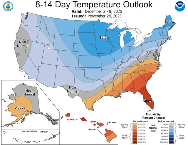
A temperature outlook from the National Weather Service (NWS) Climate Prediction Center shows a chance of below-average temperatures for the Northern Plains, Upper Midwest, Great Lakes, and part of the Northeast as a major sudden stratospheric warming (SSW) disrupts the polar vortex.
Why It Matters
Forecasters are monitoring the phenomenon, which is occurring much earlier than normal, a rare event that is expected to significantly disrupt the polar vortex in late November or early December. Such events can shift weather patterns across the United States by destabilizing the polar vortex high above the North Pole, potentially allowing frigid Arctic air to surge into North America.

What to Know
The most recent eight-to-14-day temperature outlook from the NWS Climate Prediction Center reveals some of the impacts of the SSW should it take place.
The six-to-10-day outlook also shows a high chance for below-average temperatures, although Amy Butler with the National Oceanic and Atmospheric Administration’s (NOAA) Chemical Sciences Laboratory told Newsweek that it’s unlikely that the forecast is related to the SSW.
“Right now the SSW and a build up of high atmospheric pressure over the Arctic are expected to occur simultaneously this week,” she said. “This may contribute to some of the forecasted cold, but the primary driver is probably the Alaskan ridge that is forming, which drives the jet stream south and brings cold air with it. The SSW usually takes longer to have an effect, and is likely contributing to the 8-14 day or 3-4 week temperature outlooks, which also show increased risk of cold.”
The eight- to-14-day outlook shows the highest chance of below-average temperatures will be in North Dakota, South Dakota, Nebraska, Minnesota, Iowa, Missouri, Wisconsin, Illinois, Michigan, New York, Vermont, New Hampshire, and Maine. A slightly lower chance of below-average temperatures stretches as far south as Central Texas, whereas there’s a chance of above-average temperatures in the Southeast.
Butler said there’s a chance the SSW will be “major,” but that forecasts show it on the threshold.
“So we will have to wait and see,” she told Newsweek. “Some models show it could even be happening today, while other models show maybe around Nov 28th.”
What People Are Saying
NWS Climate Prediction Center in a key message last week: “La Nina, the Madden-Julian Oscillation (MJO), and the potential for a rare November Sudden Stratospheric Warming (SSW) may combine to drive winter-like conditions across much of the U.S.”
Washington Post meteorologist Ben Noll posted on X: “A major sudden stratospheric warming event, possibly the earliest on record, is now likely to occur from late November into early December. For an event to be classified as major, it requires both a dramatic temperature rise as well as a sharp deceleration in stratospheric winds. The event’s impact — a disruption of the polar vortex — may quickly propagate from the stratosphere into the troposphere, where weather happens, displacing Arctic air southward into Canada and the United States after Thanksgiving. This pipeline of cold will be reinforced during December as high pressure becomes anchored over Russia.
“Several pulses of frigid air look likely across the United States next month, particularly in the northern half of the country. Though less certain, it seems reasonable to expect that this cold air will link up with moisture a few times, increasing chances for a snowier-than-average start to winter in some states. Stratospheric warming events are slow-moving, so don’t be surprised if it takes a little longer to ‘feel’ the impacts and if it sticks around for longer than you might expect — possibly into the new year. It will be an interesting ride.”
What Happens Next
In most areas of the U.S., temperatures have been above average in many cases, which could make the incoming cold shift feel more severe. Forecasts will continue to be issued as the SSW develops, and people living in the impacted areas should monitor local weather guidance.
Source link


