Mississippi River Flood: Map Shows Where Roads Could Be Closed ‘For Days’
April 11, 2025
4,179
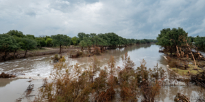
A prolonged and dangerous flood event is unfolding along the Mississippi River, where heavy rain that fell this month across the Ohio and Mississippi river basins have pushed the waterway to critical levels, prompting road closures, emergency preparations and warnings to residents.
Why It Matters
The Mississippi River is a critical transportation route for agricultural and industrial goods, and high water levels are affecting river navigation and barge movement.
AccuWeather senior meteorologist Alex Sosnowski reported that “some of the ports along the river below St. Louis may be closed due to high water,” and that tugboats will have to move with reduced loads because of increased flow speed and reduced bridge clearance.
Beyond economic concerns, tens of thousands of residents in unprotected lowlands are at risk of prolonged inundation. Levees are being tested across multiple states.
A map from AccuWeather shows where road closures could occur amid long-lasting flooding from a storm that produced torrential rainfall this month. A map from AccuWeather shows where road closures could occur amid long-lasting flooding from a storm that produced torrential rainfall this month. AccuWeather
What To Know
Communities in Mississippi, Arkansas and Louisiana are bracing for flooding expected to persist throughout the month. In Vicksburg, Mississippi, the river is projected to crest at 48 feet around April 21, according to forecasts. Farther south in Natchez, Mississippi, peak flood levels may not occur until April 22, with recovery efforts likely continuing into next month. Officials in several counties have begun closing roads and building temporary flood walls to protect homes and businesses.
“We are going to have numerous streets and roads close, including Highway 465 that runs between Highway 61 North and the Eagle Lake community,” Warren County Emergency Management Agency Director John Elfer told Jackson, Mississippi, news station WLBT.
In some of the hardest-hit areas, road closures could last “for days,” AccuWeather reported.
“When we close streets and roads, not only is it illegal but it’s dangerous for folks and motorists to bypass those barricades,” Elfer said.
Storms from April 2 to 6 damaged more than 300 homes across Mississippi, injured seven people and left one dead, according to the Mississippi Emergency Management Agency.
In Greenville, Mississippi, the river is expected to crest at 52.5 feet on April 22. Power outages and business shutdowns are anticipated as water threatens ports and grain terminals. In Natchez, similar threats loom with flooding already making roads like Carthage Point impassable.
According to AccuWeather, “as the lower end of the Ohio crests into this weekend and begins to recede during the following couple of weeks, waters will slowly rise farther downstream.”
Areas from Osceola, Arkansas, to Baton Rouge, Louisiana, are on alert, with crests not expected until late April and water levels possibly not falling back to normal until mid-May.
What People Are Saying
AccuWeather senior meteorologist Bob Smerbeck told Newsweek: “We still have a long way to go, the lower Ohio Valley is cresting this weekend, so it’s going to take a while to get into the lower Mississippi River.
“I think the weather is going to work out in the flooding’s favor, at least through the weekend. There’s some isolated storms right now, mainly east of the Mississippi and parts of Tennessee and Mississippi, but it’s very light and isolated, so we don’t expect much of a problem from those.
“Multiple rounds of showers and thunderstorms next weekend could possibly linger into the following week.”
Warren County EMA Director John Elfer told WLBT: “This is not the first time we’ve seen 48 [feet]. We saw 57.2 back in 2011 and that was a big one. We don’t anticipate that this time. Forty-eight is a moderate flood.”
What Happens Next
As the flood wave continues moving south, officials warn that the situation could worsen if additional storms hit the region. While forecasters see a brief period of drying across the Tennessee and Ohio valleys, further rain mid-next week could add to flood risks.
Um die besten Erfahrungen zu bieten, verwenden wir Technologien wie Cookies, um Geräteinformationen zu speichern und/oder darauf zuzugreifen. Wenn Sie diesen Technologien zustimmen, können wir Daten wie das Surfverhalten oder eindeutige IDs auf dieser Website verarbeiten. Die Nichteinwilligung oder der Widerruf der Einwilligung kann bestimmte Merkmale und Funktionen beeinträchtigen.
Functional
Always active
The technical storage or access is strictly necessary for the legitimate purpose of enabling the use of a specific service explicitly requested by the subscriber or user, or for the sole purpose of carrying out the transmission of a communication over an electronic communications network.
Preferences
The technical storage or access is necessary for the legitimate purpose of storing preferences that are not requested by the subscriber or user.
Statistics
The technical storage or access that is used exclusively for statistical purposes.The technical storage or access that is used exclusively for anonymous statistical purposes. Without a subpoena, voluntary compliance on the part of your Internet Service Provider, or additional records from a third party, information stored or retrieved for this purpose alone cannot usually be used to identify you.
Marketing
The technical storage or access is required to create user profiles to send advertising, or to track the user on a website or across several websites for similar marketing purposes.