-
Diddy Accused of Rape, Assault in Lawsuits Filed by Three Men, reports - 2 mins ago
-
How Covid Can Change Your Gut - 3 mins ago
-
Column: Is it time for California’s Latino Legislative Caucus to let in Republicans? - 24 mins ago
-
Why Blocking The Onion From Buying Infowars Was ‘Right Decision’—Attorney - 38 mins ago
-
European Central Bank Cuts Interest Rates as the Economy Weakens - 47 mins ago
-
Two arrested in ‘pig butchering’ that cost San José man $170,000 - about 1 hour ago
-
Churches Will No Longer Provide Sanctuary for Migrants Under Trump - about 1 hour ago
-
How America Turned Allies into Enemies in Afghanistan - 2 hours ago
-
What sleeping in prison is like: Moldy beds, bright lights, 24/7 noise - 2 hours ago
-
Mystery Thrifted Items Spark Theories Online: ‘Quest for Answers’ - 2 hours ago
Winds catapult SoCal fire warning: ‘Particularly Dangerous Situation’
With exceptional fire weather conditions forecast starting Monday night, the National Weather Service office issued a rare “Particularly Dangerous Situation” red flag warning for the coming days in Los Angeles and Ventura counties.
The last time a Particularly Dangerous Situation red flag warning was issued for the area was just a month ago, on election day, when forecasters warned of extreme fire weather behavior. A day later, on Nov. 6, the Mountain fire ignited in Ventura County and, whipped by powerful winds, razed more than 240 buildings. It became the third-most-destructive wildfire in Southern California since 2013.
Before November, the last time a Particularly Dangerous Situation red flag warning was issued by the National Weather Service office for L.A. and Ventura counties was in 2020.
National Weather Service meteorologist Robbie Munroe said Particularly Dangerous Situation red flag warnings should, on average, occur only once every three to five years. But it has now happened twice in the same fire season, just as it did in 2020 — once in October and another time in December.
Munroe warned that the “Particularly Dangerous Situation” conditions were expected to start around 10 p.m. Monday and last through 2 p.m. Tuesday. He said the extreme fire weather could be “similar in magnitude” to the howling Santa Ana wind event on Nov. 5–6 that fueled the Mountain fire.
The windy, dry and vegetation-dessicating conditions also are similar to those that kindled the Thomas fire of 2018, Southern California’s second-most-destructive fire since 2013, which destroyed more than 1,000 structures in Ventura and Santa Barbara counties. (The region’s most destructive fire in that time frame was the Woolsey fire of 2018, which destroyed more than 1,600 structures in Los Angeles and Ventura counties.)
What makes this week’s weather forecast so dangerous?

(National Weather Service)
A key focus for forecasters during this wind event will be the traditional Santa Ana wind corridors of Los Angeles and Ventura counties.
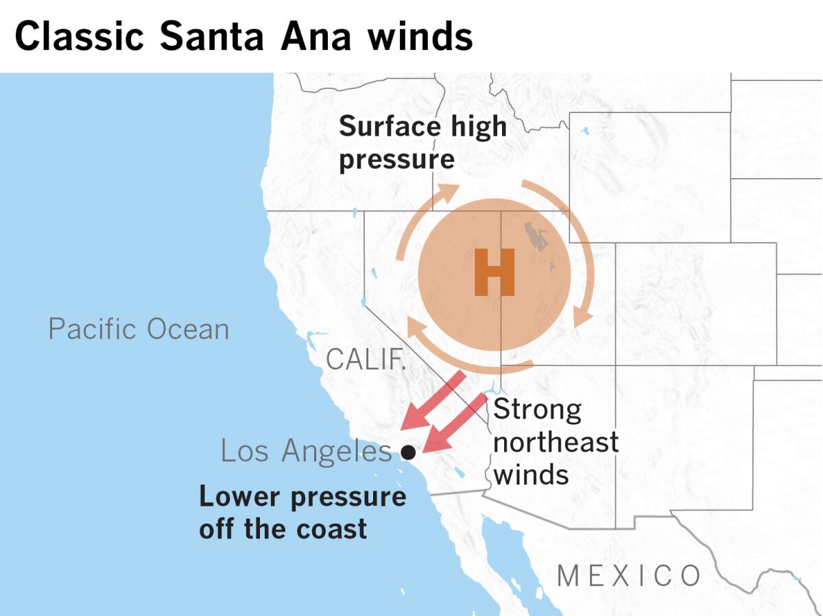
Santa Ana winds form around this time of year when a system of high pressure builds in the Great Basin — over Nevada and Utah — and then seeks a release valve off the coast, where there is low pressure.
Valleys and canyons can transform into wind tunnels in these extreme conditions. Sinking wind blows at high speeds en route to the beaches, generally in a northeast-to-southwest direction. With gusts of up to 80 mph possible, a small fire could transform into an inferno, whipping embers at astonishing speeds and leaving firefighters with few options other than trying to get people to evacuate.

(Paul Duginski / Los Angeles Times)
A Santa Ana wind corridor to watch will be that of the Santa Clara River Valley, which essentially funnels air sinking from a high pressure area above the high desert to the Ventura County coast by way of Santa Clarita.
“Rapid-fire spread is anticipated with any new fire in these wind corridors,” Munroe said. “The damaging winds will also likely lead to scattered downed trees, power lines and power outages.”
Other areas vulnerable to Santa Ana winds include the San Fernando Valley and the beaches between Ventura and Malibu.

(Paul Duginski / Los Angeles Times)
Boaters should be aware of the extreme winds, expected to be strongest in the area extending from Ventura to Malibu and offshore to the Channel Islands. Strong winds are also expected in the San Pedro Channel and Santa Catalina Island. Waves of 3 to 6 feet and coastal flooding could hit east-facing harbors, such as those on Catalina Island, Munroe said.
The criteria to issue a red flag warning that’s a Particularly Dangerous Situation includes a forecast of sustained winds of at least 35 mph and/or gusts of at least 60 mph, single-digit relative humidity, and extremely dry vegetation.
There could be peak gusts of 40 mph in Northridge, 44 mph in Oxnard, 48 in Fillmore, 52 mph in Westlake Village, 53 mph in Santa Clarita, 55 mph in Pyramid Lake and 60 mph in Acton. Munroe said there was a chance over the next two days that Southern California airports would be forced to delay flights due to strong winds.
Minimum relative humidity is expected to hit very low levels — as little as 5% in Oxnard, Fillmore, Westlake Village and Northridge; 6% in Ojai; and 7% in downtown L.A., Santa Clarita and Pasadena.
A regular red flag warning is expected to be issued for a larger portion of Southern California starting late Monday morning and continuing through Wednesday, including the San Fernando and San Gabriel valleys, the San Luis Obispo County mountains, the Inland Empire and large swaths of San Diego County.

Red flag conditions are expected in much of Southern California between Monday morning through Wednesday.
(National Weather Service)
Source link


