-
Federal Judge Drops Death Penalty Charge Against Luigi Mangione - 2 mins ago
-
Former CNN anchor Don Lemon arrested by federal agents in Los Angeles - 37 mins ago
-
The Netherlands Is Getting a New Government. Will It Last? - 46 mins ago
-
The shelter said the pit bull was sweet. He mauled his new owner - about 1 hour ago
-
How ICE Operations Are Changing Across US - about 1 hour ago
-
Will Kevin Warsh Do What Trump Wants? - about 1 hour ago
-
Law firm’s contract hiked to nearly $7.5 million in L.A. homelessness case - 2 hours ago
-
Free Buses? How About Expanding the Subway by 41 Miles Instead? - 2 hours ago
-
ICE finds targeting violent criminals increasingly fraught in backlash over indiscriminate sweeps - 3 hours ago
-
Trump Says Putin Agreed to a Weeklong Pause in Attacks Amid Extreme Cold - 3 hours ago
Winter Storm Map Shows Where Up to 12 Inches of Snow Could Strike
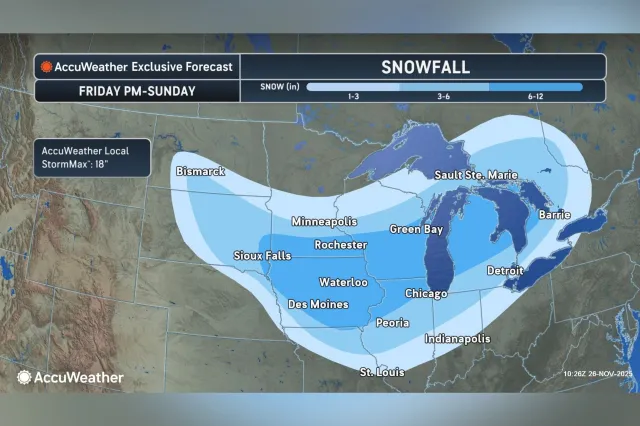
A forecast map from AccuWeather details which areas may see the snow later this week, as another winter storm is expected to form over the northern and central Rockies on Friday and move across the central Plains through the Midwest and Great Lakes this weekend.
Why It Matters
Forecasters at AccuWeather have warned that the snow delivered by the system could lead to hazardous driving conditions and accumulating snow at aviation hubs in Minneapolis and Chicago.
What To Know
“A storm tracking through the Midwest after Thanksgiving has the potential to slow travel through the weekend. Even a few inches of snow at major airports such as Chicago O’Hare or Minneapolis–St. Paul can lead to delays and cancellations for travelers heading home,” AccuWeather senior meteorologist Dan Pydynowski said in an advisory shared with Newsweek on Wednesday.
“De-icing operations and snow removal on runways can create a domino effect, with disruptions at key hubs leading to delays at airports across the country,” he added.

According to the outlet, this weekend’s storm is forecast to drop between 6 and 12 inches of snow across portions of Michigan, Wisconsin, Minnesota, Illinois, Iowa and South Dakota.
“The area that is going to see the highest snowfall is going to be across southern Minnesota and Iowa through central and southern Wisconsin through central Michigan. This area could see 6 to 12 inches,” AccuWeather senior meteorologist Tyler Roys told Newsweek on Wednesday.
He continued: “St. Louis, Indianapolis and Detroit will see a mix of snow, sleet, freezing rain and could even see rain. These locations will see upwards of a few inches of snow/sleet.
“The bigger transportation hubs of Chicago will also be impacted, while the highest snowfall is likely to be to the north of them. Given the airports and highways around, significant delays and even cancellations are expected.”
“Given this storm is not expected to feature lake-effect or very gusty winds, road closures like what is expected in the current storm are not anticipated. There could be road closures that are weather related but are more likely from accidents,” Roys added.
Blizzard warnings and winter storm warnings from the National Weather Service (NWS) already spanned parts of Michigan and Wisconsin as of early Thursday, with additional winter weather advisories and lake-effect snow warnings covering parts of Pennsylvania, New York and Ohio.
Michigan’s Alger County is expected to see snow accumulations between 4 and 13 inches of snow and hazardous conditions that will affect holiday travel, according to a blizzard warning for the area that is in effect until 7 p.m. Eastern time as of reporting.
What People Are Saying
AccuWeather senior meteorologist Dan Pydynowski said in an advisory: “People returning home from the holiday and those heading out shopping should be prepared for slippery and hazardous road conditions across parts of the Midwest. Drivers should keep winter emergency supplies, blankets, bottled water, snacks and a fully charged phone in their vehicle.”
What Happens Next
Regional NWS branches regularly issue forecast updates via the agency’s website and social media channels.
Source link


