-
How to Watch Florida vs Ole Miss: Live Stream NCAA College Football, TV Channel - 6 mins ago
-
Todd Snider, Folk Singer With a Wry Wit, Dies at 59 - 7 mins ago
-
Texas A&M HC Mike Elko Makes Strong Statement After Aggies’ Comeback Win - 41 mins ago
-
Indictment of ex-Newsom aide hints at feds’ probe into state investigation - 43 mins ago
-
Dar Global Is the Trump Organization’s Key Foreign Partner - 51 mins ago
-
Zach Edey Injury News Will Give Grizzlies Major Boost - about 1 hour ago
-
Fetterman Is Released From the Hospital After a Fall - 2 hours ago
-
Mike Vrabel, Patriots Receive Brutal Injury News After Jets Win - 2 hours ago
-
4 dead after panga boat capsizes off California coast - 2 hours ago
-
On a Clipped Wing, Flamingo Escapes a British Zoo for a Life in France - 2 hours ago
Winter Weather Map Shows ‘Big-Time Cold Front’ Set to Hit US
Parts of the U.S. could see a “significant” cold snap early next week, according to forecasters.
Why It Matters
“There definitely appears to be a significant cold spell late this weekend into early next week from the Great Lakes into the Ohio Valley and East,” AccuWeather meteorologist Adam Douty told Newsweek. “This has the potential to be the most-significant period of cold we have seen so far this fall as a storm pulls colder air south from central and northern Canada.”
What To Know
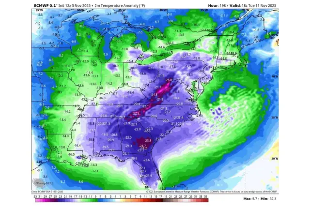
A map shared by storm chaser Stephen Jones on Monday suggested a broad swath of the Eastern U.S. could see notable departures from average temperatures next week.
“Big-time cold front next week,” wrote Jones. “Across the Eastern Half of the U.S. This may allow for snow as far south as the Southern Appalachian Mountains with temperatures being 15-25 degrees below average.”

Douty told Newsweek that the cold would first move into the Great Lakes area on Sunday, then into the East Sunday night and into Monday.
Parts of the Southeast could see their first frost or freeze of the season, Douty said, ending the growing season across areas of Mississippi, Georgia, and potentially northern Florida that have yet to experience a frost or freeze.
“This can also bring the first bout of accumulating lake effect snow of the season from Michigan and northern Indiana into western Pennsylvania and New York,” said the meteorologist, adding that parts of the Ohio Valley could see their first snowflakes of the season.
The southern Appalachians in Tennessee and North Carolina could also receive light snow accumulations, though this wouldn’t be unusual for this time of year, Douty said.
“The cold will be fairly transient, however, with milder air returning by the middle of next week,” the meteorologist added.
What People Are Saying
Meteorologist Payton Malone said in a Monday Facebook post: “Thinking we see our strongest cold front of the season early next week. Some might get a little frosty …”
Meteorologist Rachel Duensing said in a post on X, Monday: “This week should be lovely: highs in the upper 60s and low 70s and plenty of sunshine! But this weekend a strong cold front arrives which could bring us our first real shot of chilly (dare I say cold!) air next week. We’ll watch it closely.”
The National Weather Service (NWS) forecast office for Baltimore-Washington said on X, Tuesday: “Seasonable temps with more sun than clouds today. Breezy this pm. A warming trend for midweek with high pressure. Temps on the warm side midweek, before a strong cold front pushes through the region & brings a gusty and chilly wind behind it. A second front late week around Friday.”
What Happens Next
Regional NWS branches issue frequent local forecast updates on the agency’s website and social-media channels.
Source link


